Sunday, October 12, 2014

Moab to Grand Canyon ~ North Rim

Please double click on each pic to get a larger look (you can't get the full impact on your cell phone!) 

 ;-)

                                                 Broken Arch in Arches National Park

Thanks for Joining us on our Trip!!  
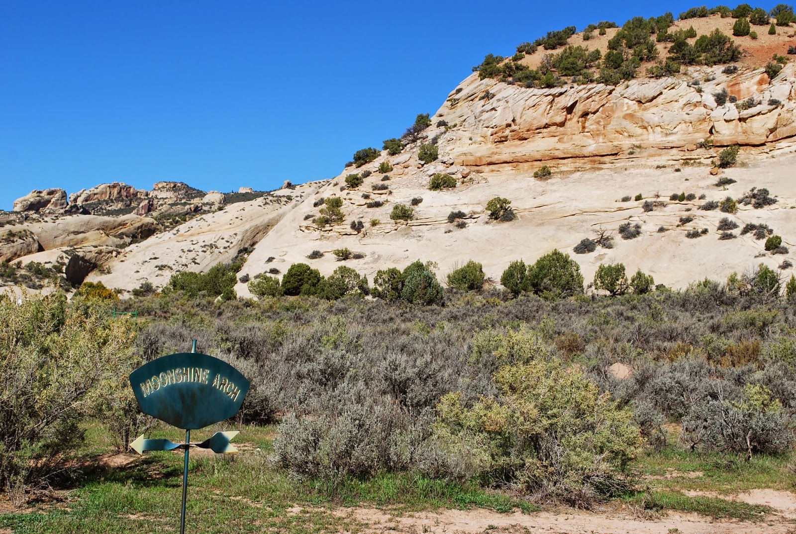
We are back in Utah and after leaving Colorado and Grand Mesa we ventured west to the Moab area of Utah which is one of our favorite places - with 2 National Parks and amazing scenery every way you turn.  We stayed out on Hwy 128 which runs north from Moab along the Colorado River and is a beautiful scenic drive.  We stayed at a BLM campground on the river  about 6 miles from Moab and Arches National Park.  There is a paved separate biked trail that runs along the river all the way to Arches and it was a great way to see the surrounding area.
   
                                           Ready to roll down the Colorado to Arches N.P.

 We also took various drives in the area along with the amazing 26 mile round trip through Arches we did the Castle Valley Loop, Sand Flats Rec Area, and the Colorado River road going south out of Moab and features petroglyphs, dinosaur tracks, rock climbers, amazing views along the river, and a great hike to 2 arches (Bowtie and Corona).


                                               Moon rise over our camp on the Colorado

                                                "Blue" bird at Camp...... (ID anyone??)

                                                             Overlook of Castle Valley

                                            Peek a boo view of the La Salle Mtns.
    
                                                                  Desert Bloom

                                              The Colorado on the way to Corona Arch

                                                Cairn Garden on the hike to Corona Arch

                                                         Bow Tie (left) and Corona Arch

                                           Corona Arch with Carol on left

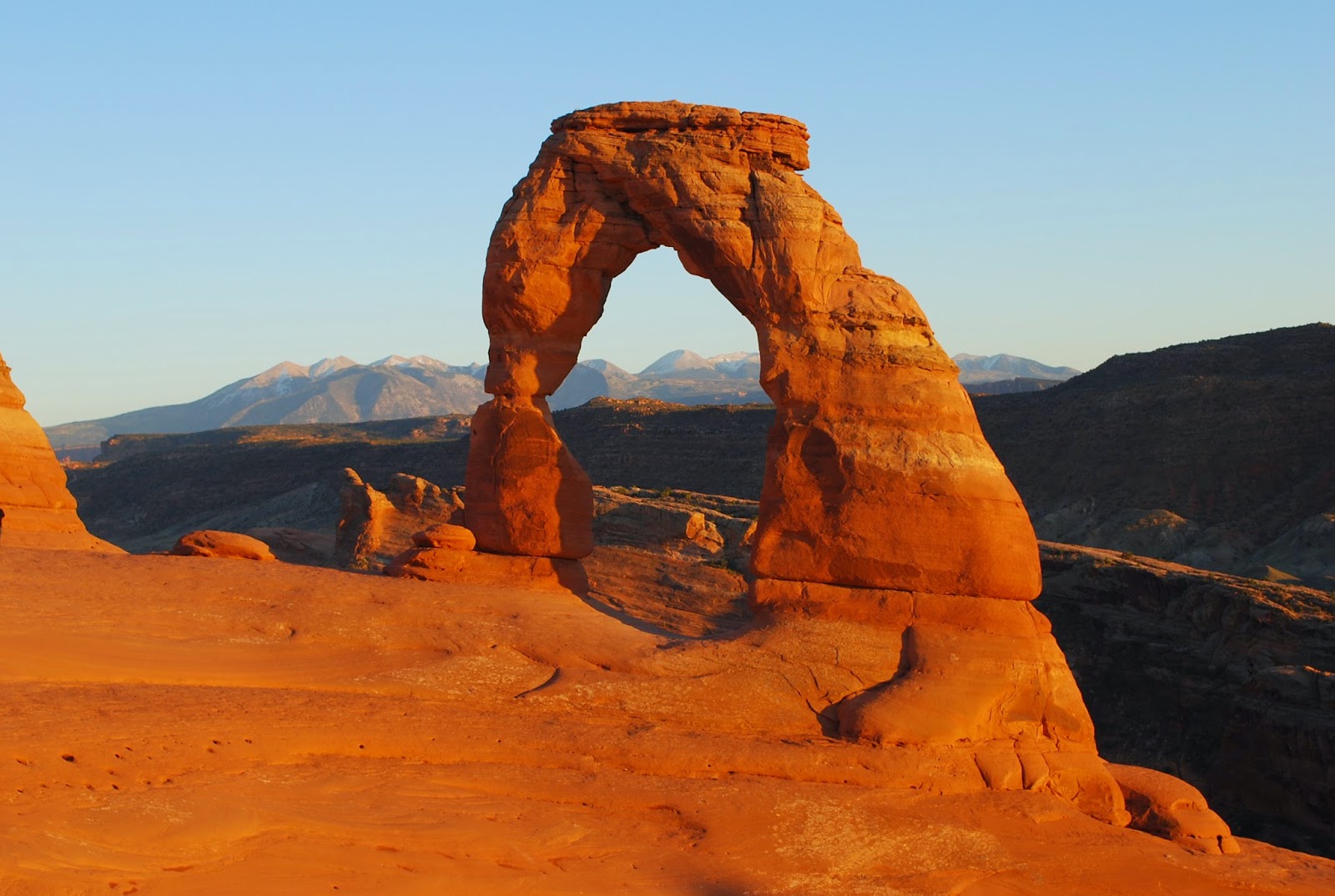
    The most famous arch in Arches NP is Delicate Arch -  and we have done the amazing hike to it twice before -  so this time we did it at sunset and it was a special treat.


                                             Delicate Arch with La Salle Mtns. Backdrop

                                               "The Scene" at Sunset"


                              Valley of the Gods is in SE Utah just north of AZ border
                                      This formation is called Balanced Rock and the one below
                 is called Lady in a Bathtub ~ they are the same rock from a different angle

                                                            Valley of the Gods View

                                               Valley of the Gods View

                            This is how the nearby town of "Mexican Hat" got its name!

From SE Utah we drove into Arizona through Monument Valley, along theVermillion Cliffs to the North Rim of the Grand Canyon.  This was another must for our "Fall" trip as it closes on October 15th every year because of snow at the high elevation (over 8,000') and our former winter travel window precluded going there.
It has been years since we went to the South Rim - and really have no desire to return as it is such a tourist mob scene (more like a city than a National Park ~ Edward Abbey's worst nightmare).
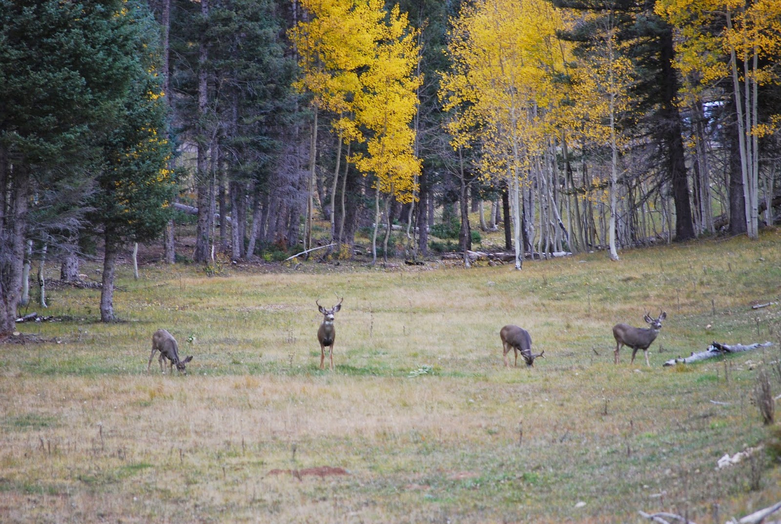
   In any case the North Rim is completely different and we think more beautiful.
it also reminded us of Yellowstone with beautiful foliage, high plateau and lots of wildlife ~ deer, bison, coyote, etc.
 
                                                                      Buck Fever!

                         Carol below the Lodge on the North Rim on Bright Angel Point Trail

                                     Angel Arch at Cape Royal on North Rim

                                                                   Close to the Edge!

            Quaking Aspen Everywhere on the Drive (I am sure I have 100 pics of them!

Thanks Again for Joining us!  We are now in Kanab, Utah for a Week and this was another area we knew we wanted to explore.  We are very excited as we send this out as we just won the lottery today for "The Wave" which only pics 10 people per day for the next day to hike one of themost scenic wilderness areas on the planet!

here is a little teaser:
            http://en.wikipedia.org/wiki/The_Wave,_Arizona


But that is for next time.......Our best to you all !!!!
Don and Carol

Saturday, October 4, 2014

Grand Mesa and Colorado National Monument


Grand Mesa, Colorado N.M. and
 Black Canyon of the Gunnison N.P.

 From Dinosaur N.M. we wound our way on backroads into Northwest Colorado in the area of Grand Junction and are spending a week on Grand Mesa - at the Powderhorn Ski Resort.  When we got here on Saturday the weather was in the high 70's and blue skies - but since then we have experienced snow, hail, and temperatures down in the 20's.   Our timing was perfect to have our week of timeshare (that we traded into) happen with the abrupt weather change.  
     This is a beautiful area with many scenic drives, quaint small towns, amazing National Monument in the Colorado N.M., and Grand Mesa itself.

The Grand Mesa is a large mesa in western Colorado in the U.S.   It is the largest flat-topped mountain in the entire world, has an area of about 500 square miles, and stretches for about 40 miles east of Grand Junction between the Colorado and Gunnison Rivers.  The mesa itself is formed from a basalt flow - some 10 million years ago that filled a valley and being harder than the surrounding area remained while the surrounding area was eroded away from the 2 rivers.  After the receding of the ice age some 15,000 years ago the mesa top was eroded further and left with more than 300 lakes.

                                   Heading into the high country of Grand Mesa
                                         Hillside above our Condo when we arrived

                           
After the Snowfall

                                                                         Aspen
                                                     Moon Rise over Grand Mesa

A National Monument that we visited once before is Colorado N.M. which is at the back door of Grand Junction, CO.

The Colorado National Monument raises up nearly 2000 feet above the Grand Valley, and is 32 square miles of total area. It is located on the edge of the Uncompagre Uplift which contains geological phenomenon like the Grand Canyon and Arches. The Monument is made up of mesas, buttes, buttresses, pilars, and spires. Many forms contained in the Monument have been formed by wind and water erosion. The rock strata has been forming for over 1.5 billion years, and has been laid down in sequential order. There are nine different rock formations


                                                           trail to Devil's Kitchen
                                                                      Devil's Kitchen
                                                                     We made it!!
                                                   Don't get too close to the edge


Our last Day at Grand Mesa -  we headed south across the mesa and into the Delta/Montrose area which is most famous for Black Canyon of the Gunnison N.P.
This is a 2 million year old canyon of volcanic rock including Gneiss, Schist, and veins of lighter colored pegmatite.  The Gunnison River is in a very narrow, steep walled canyon because it drops an average of 34 feet per mile (6.4 m/km) through the entire canyon, making it the 5th steepest mountain descent in North America. By comparison, the Colorado River drops an average of 7.5 feet per mile (1.42 m/km) through the Grand Canyon.


Thanks for joining us on our trek!

Don & Carol

Thursday, October 2, 2014

Dinosaur National Monument

   
    Many of you know how much Carol and I are drawn the the Southwest.  We have been to various parts of it over the years at least 8 or 9 times and it is always fun to revisit favorite places and to explore new ones.  We spent more time in southern Utah than anywhere and are looking forward to returning in a few days when we leave the Grand Mesa area of Colorado, but on this go around we are seeing areas that we have not previously visited.
    Since leaving Wyoming we've spent 3 days at Dinosaur National Monument which spans 2 states ~ at its western side is near Vernal, Utah and crosses into Colorado.

Dinosaur National Monument is located on the southeast flank of the Uinta Mountains on the border between Colorado and Utah at the confluence of the Green and Yampa Rivers.  This park has fossils of dinosaurs including Allosaurus, Abydosaurus (a nearly complete skull, lower jaws and first four neck vertebrae of the specimen DINO 16488 found here) and various long-neck, long-tail sauropods. It was declared a National Monument on October 4, 1915.
Geology:
The rock layer enclosing the fossils is a sandstone and conglomerate bed of alluvial or river bed origin known as the Morrison Formation from the Jurassic Period some 150 million years old. The dinosaurs and other ancient animals were washed into the area and buried presumably during flooding events.   The pile of sediments were later buried and lithified into solid rock. The layers of rock were later uplifted and tilted to their present angle by the mountain building forces that formed the Uintas. The relentless forces of erosion exposed the layers at the surface to be found by paleontologists.
The Quarry:
The "Dinosaur Wall" located within the Dinosaur Quarry building in the park consists of a steeply tilted (67° from horizontal) rock layer which contains hundreds of dinosaur fossils. The enclosing rock has been chipped away to reveal the fossil bones intact for public viewing.

 Besides the amazing concentration of Dinosaur fossils the scenic vistas, flora, and geology in the Monument are alone worth time spent there.
     So now that you are up to speed -  I would like to share some pictures or our time there.


                                                    Visitor Center

                                            Dinosaur Wall:   Bones, Bones, and more Bones

                                                 Carol hangin' with and Allosaurus femur

                                  close encounters of the Jurassic Park kind

                                 Split Mountain with uplifted layers of sedimentary rock

                                      Chillin' at our campsite on the Green River in the Park

                                                          Campsite at Dinosaur N.M.

                                    The Dinosaur Quarry Building from the Fossil Trail

 While at Dinosaur ~  We also visited a wonderful museum in Vernal and other sites famous for natural geology and petroglyphs.  One such place we visited is Moonshine Arch which is a fantastic arch on private land that allows access and is an amazing example of natural erosion.
                                                                Moonshine Arch Trail

                                            Long uphill climb on slick rock in 85 degree heat!

                                                             The Reward: Moonshine Arch

                                                        Can you spot Carol?


We also visited McConkie Ranch in Dry Creek Canyon - about 10 miles outside of Vernal.  There are hundreds of petroglyphs from the Fremont period on this beautiful sandstone cliff stretching over a mile.
The rock art located up Dry Fork Canyon is world renowned and located along a 200-foot-high "Navajo Formation" sandstone cliff. These petroglyphs are located on the Sadie McConkie Ranch, a private property, but have remained accessible to the public, all they ask is that visitors do not damage the sites, and obey all signs. Nowhere else can you see more petroglyphs in one area that are so easily accessible.
There are trails that take you up close and personal were you can view figures up to 9 feet tall. These figures represent the Fremont culture, which flourished in this area from about 1-1200 A.D. You may spend any were from 1 to 8 hours exploring this area, depending on how far you want to hike and how much you want to see.
                                   The turnoff about 10 miles out of Vernal, UT

    The Ranch

                                                  Carol at the Navajo Sandstone Wall

                               More than a mile of Petroglyphs along the base of this wall
                                                                 
                                               A few of the many Petroglyphs

                                                         Carol at the Petroglyphs

An other place we visited was an eerie and very strange area called Fantasy Canyon.
I have included a link to a BLM page that describes this unique geologic feature:
http://www.blm.gov/ut/st/en/fo/vernal/recreation_/fantasy_canyon.html


Well ~ thanks for joining us on our journey and we hope you are all well and we will stay in touch!

Don and Carol